By Kelly Mundell and Jess Fierro
|
|
|
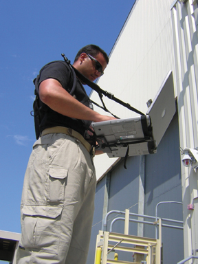
Tactical Survey technician gathering data (Photo by WFI Government Services, Inc.)
|
We have all seen images of crisis situations as they unfold on television: the Oklahoma City federal building bombing, the Columbine High School murders in Littleton, Colorado, the World Trade Center attack in New York City on September 11th, 2001, and most recently, the Superdome and Convention Center in New Orleans, following Hurricane Katrina. There are many other examples, as well. But, whether the crisis was natural or man-made, we saw first responders placed in the awkward position of trying to control a seemingly uncontrollable situation at a facility about which they knew very little. Many of these responders were at these locations for the first time. The questions that these men and women faced in each situation were strikingly similar: Whats inside? What other agencies are responding? Whos in charge? How do we get inside and back out quickly without being noticed or becoming a casualty? How do we shut off power/ alarms/ other utilities?
LACK OF INFORMATION, THE SECOND CRISIS
Had all of these emergency professionals had the opportunity to become familiar with the facility ahead of time by walking every hall way, entering every room, speaking with the building administrative, maintenance, and operational personnel, they would have had much of the information that they needed up front, in time, to make the correct, or at least, a better decision on how to engage the crisis. Before systems such as a computer-based security tool that presents a virtual tour of a structure became available, the only way to gain this detailed knowledge was by visiting the site numerous times or sitting down with the appropriate experts. Today, first responders from military facilities to federal and local government agencies to airports are all using computer-based security systems like Tactical Survey for incident response, training, and improving overall readiness. The Tactical Survey system allows users of the system to virtually walk through every square foot of a structure without ever physically passing through its doors.
The system was invented by the Tactical Survey Group (TSG) of San Bernadino, California to prevent chaotic situations like those mentioned above from exacerbating the efforts of first responders. WFI Government Services, Inc. has partnered with TSG to further develop and deliver the technology to government and commercial clients.
|
|
|
|
|
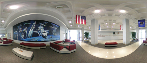
Tactical Survey is a "tactical" geographic information system allowing emergency personnel to view critical facilities from beyond the crisis location before having to enter the affected facility. (Photo by WFI Government Services, Inc.) |
VIEW FROM BEYOND
The most effective way to enhance readiness is through thorough training of the emergency response organization with emphasis on personnel qualifications (watch team positions), firearms, and protocols. The protocol, or procedures, training is vitally important, especially when it is location, or facility specific. This is where computer-based technologies save time, resources, and possibly lives. Knowing the Area of Responsibility or AOR, first responders are best equipped to manage a crisis situation. Information is key: site location address, latitude/ longitude for tactical or MEDIVAC aircraft, aerial imagery, ingress/ egress points, key utility locations and shut-off procedures, fire pre-incident plans, alarm and communications infrastructure, building composition, key facility personnel, inter-agency coordination contact information, and more. Having these critical data are even more urgent when the facility is complex (such as an airport, convention center, government or military laboratory, conventional or nuclear refinery) or due to its proximity to densely populated areas.
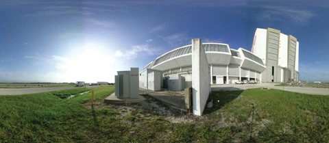
The Tactical Survey System (TSS) is a "Tactical" geographic information system allowing emergency personnel to view critical facilities from beyond the crisis location (in headquarters briefing rooms, at incident command posts, in emergency vehicles, etc.) before having to enter the affected facility. The system looks like a "virtual tour" of a structure, only, far more robust with embedded tactical information on these spherical images. The users of the system can "see through" doors, walls and around corners to view where someone could be injured or hiding. Moreover, they can look up, down, right and left in a seamlessly fluid 360 degrees. Digital images are embedded in accurate, field-verified geographic maps. Other embedded tactical data includes hazardous material types and locations, and perimeter control systems. With such a system deployed, emergency responders arrive at the scene with the tool necessary to give them detailed knowledge of a given building or facility.
The benefit of having a computer-based security tool is that the most critical information needed during the crisis is available quickly, via redundant, built-in, visual data access tools which are intuitive and easy to operate during emergencies. This particular tool requires only a standard computer with an Internet browser and no other special equipment requirements. The tool can also run on smaller, more portable clients such as laptops, PDAs, and some late generation cellular phones. It can be completely mobile with or without a wireless signal as the software can be installed on a computer hard drive. Without the benefit of a computer-based security system, critical information is normally found in three-ring binders on office bookshelves, or widely dispersed as part of an organizations corporate knowledge -- largely inaccessible during an emergency.
SMALLER, BUT SMARTER
The Tactical Survey system was released in August of 2001 as an incident response tool for first responders. Following the events of September 11th later that year, the TSS was already a robust software tool available for crisis response. However, in the years following, many other technologies have emerged as viable tools in enhancing both physical and IT security, including biometrics, sophisticated network firewalls and sensors (visual, aural, substance, environmental, etc.) that provide time and cost saving benefits. It is through the use of computers that these technologies are being implemented and integrated. Most of the newest systems are on networks with discreet Internet Protocol (IP) addresses for key components or sensors which communicate with each other through servers. This type of architecture lends easily for integration with other server-based systems and components.
For example, WFI performed a limited Tactical Survey of its own facility headquarters in San Diego, California. The system is a sophisticated electronic archive of key information in that facility. Should an emergency occur at the WFI facility, first responders would have this information to facilitate their response. However, the company took the system a step further by integrating their server-based camera, door access, and fire-life-safety systems for real time functionality to benefit users of the survey tool. Now, everyday survey users, such as the company? security staff, can use the survey to monitor these systems seamlessly, as each complements the other for personnel and facility safety. The survey provides the information and access to the entire facility to those charged with its safeguard on a computer screen. Logically, facilities with an installed and fully integrated Tactical Survey system would conceivably have less safety and security operating costs due to a smaller and smarter guard or security staff.
Smaller and smarter is largely the approach that the U.S. Government has taken in its approach to the military. Ships, aircraft, and land vehicles today have the most advanced command, control, communications, and computer systems in the world. They are smaller and lighter than ever before. Because the government has embraced technology in this manner, we have smaller ships which require less (although more educated) personnel, faster aircraft with more precise weapons guidance systems, and less troops on the ground due to the support of these compensating technologies. However, machines and technology cannot completely replace people, and finding the right balance between technology and manning is a delicate endeavor which organizations must manage carefully as the two are blended.
DON’T GO THERE WITHOUT KNOWING THE TERRAIN AHEAD
Along with the benefits from technologies like the Tactical Survey system come great responsibilities for their own protection. A useful tool in the appropriate hands can also be useful in the wrong hands. Recipients of the Tactical Survey system, most of which are from government agencies, recognize the security aspects associated with protecting sensitive information and therefore have robust security guidelines and requirements for storage and sharing of this information. Each government agency has its own security criteria appropriate to its own organization and mission. When WFI installs a Tactical Survey, it does so in accordance with the recipients security guidelines. Once installed, the information is maintained to the high standards of the organization which are sufficient for its purposes.
Moreover, effective security preparedness and response means having the appropriate policies, procedures, tools and training for the emergency organizations. Ideally, these four aspects of preparedness will meet all of the safety and security requirements placed on that agency, business, facility, or organization by higher authorities. This is where having the right tool is so important. The tool must be able to meet numerous requirements and hopefully replace other redundant, ineffective, or obsolete tools or mechanisms.
Ultimately, there is no question that having the right security tool is as important as the assets it protects. It must be operationally effective, provide economies when incorporated with other technologies, affordable, and accessible to its proper users.
-------------------------------------------------------------------------------------------------
Kelly Mundell is General Manager of Homeland Security & Public Safety Applications of WFI Government Services, Inc. (www.wfinet.com)
Jess Fierro is Program Manager of Homeland Security & Public Safety Applications of WFI Government Services, Inc. (www.wfinet.com)
For more information, please send your e-mails to swm@infothe.com.
ⓒ2007 www.SecurityWorldMag.com. All rights reserved.
|